 (source: John Nicholson)
The path goes right under the window of our hotel room so no excuses for a late start. So at exactly 9:39 we set off. We are not the get up at the crack of dawn and walk all day sort of people. This is supposed to be fun. Therefore, we try to start reasonably, walk not too long, and stop to smell the roses, and occasionally fertilise them.
If a walk takes us 9 hours, then on average we will only have walked for 6 hours. We are stationary for whatever reason for about a third of the time. If it’s pretty we will stop to photo it, stare at it, or given how much we are drinking, pee on it. We will never win a race but we will finish.
Read more:
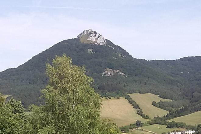
Today is another fantastic day in the trees. I think who ever selected the route was agoraphobic.
The first time we leave the forest and enter a field we cannot find the path out of the field. We checked the map, we knew where we were. We checked Google Maps, we were in a green bit. We got a grid reference from our watch, we knew exactly where we were and found it approximately on the map. We weren’t lost, we just couldn’t find the exit. I don’t know what would have happened if there had been a fire.
 (source: John Nicholson)
We split up, someone going back up the hill to make sure we hadn’t missed a turn off, guess who is someone. The others off in three other directions to scout around. Eventually, after trampling most of the grass in the field looking everywhere three times. I went to look where the wife had been, obviously my instructions had not been clear, and found the path straight away. Twenty meters from where we had dropped our rucksacks. We did that twenty meter at about 40m per hour.
As we approach Horná Poruba we came out of the trees so we able to appreciate the full scenicfullnessness of the area. I haven’t met anyone who has heard of Horná Poruba but it’s a nice little village with a nice little pub, that fed and watered us.
Accommodation here had been hard to find. Eventually, a call to the local mayor resulted in the name and number of an old school teacher who took people in. All of the alarms in my head where going off. The image I had built up was of a gingerbread house surrounded by fat birds who had eaten all of the bread crumbs.
The lady was lovely, took people in to survive. The house old but unfinished. The furniture, that of an old school teacher. But she was lovely and loved to talk. We shared the place with a couple of lumberjacks. We have the contact details, just ask.
Distance walked: 15km (253km in total)
Meters climbed: 810m (8,338m in total)
Walking time: 5:17 (81:26 in total)
Start point: Trenčianske Teplice
End point: Horná Poruba
General comment
Lost the track in a field. We all looked but the blind person walked past the track. I didn’t shout. Much.
But we had a nice aroma as we left the hotel.
Cho Oyu – 8,188 meters the sixth highest mountain in the world, Nepal. Only 510m to go.
By John Nicholson
