
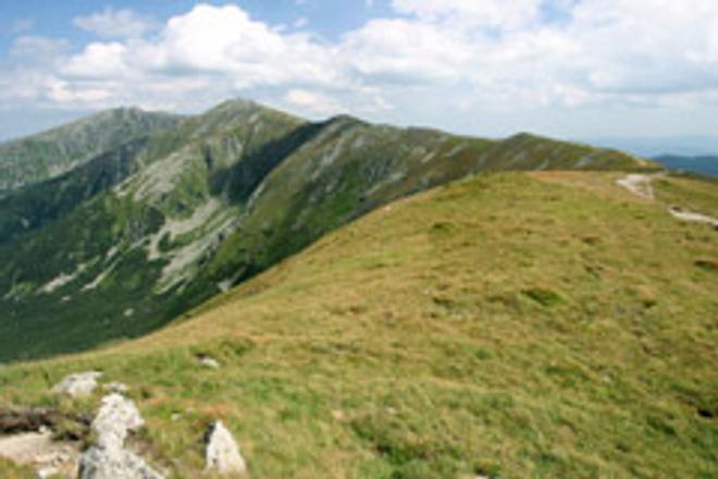
 The SNP trail takes you along the main ridges of some of Slovakia’s most beautiful mountain chains. (source: Courtesy www.hiking.sk)
Crossing Slovakia on foot is a challenge for any hiker. You have to be willing to spend about a month on the road, and you have to be able to learn from your mistakes, to handle sudden changes in the weather, hunger and the possibility of getting lost. It’s the kind of trip that will show the true characters of everyone traveling in a group. It’s an adventure that will take you far from civilization.
The trail that will take you across the country is called the Path of the Heroes of the Slovak National Uprising (Cesta hrdinov SNP), because it snakes through remote upland areas that were refuges for the partisans fighting the Nazis during the latter stages of the Second World War. In the east it begins in the Dukla Pass on the Slovak-Polish border, the site of a famous tank battle, and heads south through Košice. From there it bends west through the Low Tatras and Veľká Fatra mountain ranges until the Czech border, where it turns south to a memorial at Bradlo in the Small Carpathians. Here the SNP trail ends, and a red-marked path called the General Milan Rastislav Štefánik Magistral continues to the Devín Castle through the Carpathians. All told, it’s 744 kilometers long, signed with red blaze marks, and is known at the Slovak section of the E8 international hiking route. The best time to hike it is in July, when all of the mountain chalets are open for business and there is plenty of daylight.
Dukla pass to Košice
We recommend that you start in the east at the Dukla Pass and head west to Devín. This part of the trail requires more physical and emotional fortitude because of the neglected state of the trail markings and the scarcity of accommodation. It’s best to tackle it when you’re at full strength.
The Dukla Pass, on the Polish border, is best known for its memorial to the Carpathian-Dukla operation of the Second World War, when Soviet and Czechoslovak troops battled southwards to liberate Slovakia from the Germans. Over 46,000 soldiers died and 93,000 were wounded. An open military museum with exhibits of tanks and airplanes is one of the main modern attractions of the area.
The village nearest to the SNP trailhead that is served by bus is Vyšný Komárnik, right on the Polish border. Make sure you fill up your water bottles, as you cannot count on coming across springs. The largest nearby town is Svidník, after which most of the trail is asphalt. You can find accommodation in Svidník, or set up your tent near the town. Svídnik has an attractive open-air museum of Ukrainian and Ruthenian culture.
The trail continues mostly through the woods to Zborov, where you will find a castle and a campground under its walls. From Zborov, proceed to the Stebnícka Magura hill, where you will find a transmitter and a hiking gazebo. The trail leads on to the Bardejov Spa, where you will find several springs. While you are there, you should check out the nearby town of Bardejov with its beautiful historical core.
From there it’s off to Hervartov, the site of a typical east-Slovak wooden church. The SNP trail then takes us into the Čergov uplands. After scaling a hill by the same name you come to the Čergov pass, where you will find a hiking chalet with refreshments. You can also stay overnight here, but you shouldn’t count on a bed being available. The trail takes you onwards, out of the woods along agricultural roads to the town of Veľký Šariš (try taking the yellow path up to the nearby Šariš Castle). Our red path goes through several villages, among them Cemjate, where you will find a mineral spring. Just past Ľubovce at the Prokop Mill crossroads there is another popular sleeping spot offering a tap with drinking water.
From here to the town of Kysak there is an asphalt road, while between Kysak and Košice you will pass the Jánošíkova bašta lookout. You are now in the Volovské vrchy range. The Hrešná chalet is a common overnight spot before reaching Košice.
Košice to the Low Tatras
From Slovakia’s second-largest city we head west. The trail takes you though more civilized country, past the Bankov Hotel and the Jahodná and Lajoška chalets to Kojšovská hoľa, a ski center that in summer offers no refreshments or accommodation, so you’ll have to rely on your own tent and supplies. You’ll find a spring about 1.5 hours further on at the Tri studne crossroads, shortly before the Kloptáň summit, where there is a large hiking gazebo. The trail takes you past Štós, where you can buy supplies, and then back into the woods. Under the Skalisko peak you will find the Volovec hiking chalet, where you can sleep and eat.
The SNP trail takes us onwards towards the Slovenský raj national park and the Palcmalnská Maša reservoir, which it skirts to the south over the Dobšinský hill. You can head into the Dedinky village to buy supplies, but it’s quite a long detour. If you stay on the path you will soon reach the Gápli chateau with its fireplace, water and cover. After the Besník saddle we come to Telgárt and the entrance to the Low Tatras national park.
The ridge of the Low Tatras mountain chain is heavily visited in the summer months, so after days of relative solitude be prepared for lots of people on the trails. On the other hand, there are also many more places where you will find a bed for the night. If you are intent on camping, be aware that in the national park you can only set up your tend in designated areas, usually very close to chalets. We recommend that you stock up on food and water in the village of Telgárt, before taking the steep trail to Kráľova hoľa with its transmitter and breathtaking views. If you want to camp here, you have to take the blue trail about an hour down to Predné sedlo, where tents are allowed. The closest place to stay if you want to remain on the ridge is the Andrejcová shelter, about three hours hike from Kráľova hola. The Andrejcová shelter is newly reconstructed, and offers a spring. Shelters in the Low Tatras can be used for one night only.
Past Andrejcová, you will encounter a section that is poorly marked after a windstorm in 2004 knocked down most of the trees. If it proves beyond you, try going back to the Priehyba pass, from where you can take the blue trail to Heľpa, and then a bus to Brezno. In Brezno you can get another bus that will take you to the Čertovica pass, where you can join the second half of the Low Tatras ridge hike. If, on the other hand, you find your way through the fallen trees section, you will eventually reach the Ramža shelter. You can sleep either here or two hours’ walk further on at the Čertovica pass, where you are allowed to set up a tent.
At this point you come to one of the most beautiful parts of the whole SNP trail. About three hours from Čertovica you will reach the Milan Rastislav Štefánik chalet beneath the Ďumbier peak. The chalet offers accommodation and refreshment, and you can also stock up on your water supply. From the Krúpové pass you can reach Ďumbier, the highest peak in the Low Tatras, with its panoramic view. The red trail leads on to the Chopok peak, one of the country’s most popular ski spots in winter. The Kamenná chata chalet offers accommodation and food, as well as cool T-shirts, although water is in short supply. If you have the energy, trot up to the summit of Chopok, where you will get a great view. From here, follow the ridge to the Ďurková shelter under the peak of the same name. A short distance away you will find a spring. The rest of the ridge trail is not so frequented by hikers, and ends with a steep descent from Prašiva to the Hiadeľského pass. Here is another spring and a camping spot, or you can continue three hours to Donovaly, where you will find grocery stores and hotels.
Donovaly to Trenčín
From Donovaly we enter the Veľká Fatra mountain range, one of the wildest spots in the country. The trail leads over the Zvolen peak and rises and falls until we get to the Krížna peak, where there is a military transmitter. This part of the trail also offers excellent views, and leads past the Kráľova studňa chalet, which unfortunately is under reconstruction at the moment. Not far off is an abandoned shepherd’s cabin where you can sleep. It’s a good idea to fill up on water above the hotel.
SNP leads on to the Malý Šturec pass, where it hooks up with the main road through the mountains. After crossing the road you will reach the Kremnica hills. The trail goes through Skalka, a well-known cross-country skiing spot above the gorgeous town of Kremnica. There are various chalets here where you can get food and drink. You will also pass a spot that claims to be the geographic center of Europe, near a monastery where you are usually allowed to pitch a tent and fill up on water.
The next section is flat, leading through fields and villages until we get to the Žiar hills, where you can hike up to Bralová skala for a view of Handlová. This is another section where you will have to rely on what you carry in your backpack. Another interesting lookout point is Vyšehrad, from where you can see the whole Turčianská valley. A short ways after you will encounter a spring at the Hadviga crossroads, from where the trail leads on to the Fačkovské pass and Čičmany, on the southern border of the Malá Fatra national park.
From Čičmany, the trail leads to the Strážovské hills and Strážov peak, with its gorgeous view. From Strážov you descend to the village of Zliechov, and along the way you can fill up on water. A steep hike follows up to the Vápeč lookout point, and to the Omšenská baba lookout, before you reach the spa town of Trenčianske Teplice. From here it’s not far to Trenčín and its beautiful castle.
Trenčín to Devín
From Trenčín the SNP trail leads over the Váh River to the Zlatovce village and over the fields to Drietomy, before rising to Ihriská in the White Carpathians range. Here the trail crosses the Czech border and takes us down off the ridge into Kykule, although now that both countries are part of the Schengen zone, you won’t need your passport. You can eat on Mikulčin peak and fill up your water bottles. The trail is part asphalt, part forest path until we come back over the border at Veľká Javorina. There is accommodation and food at Holubyho chalet.
The red path leads under the Durda peak, where you will find a spring, and then through the forest and along the road to Myjava. Here the SNP heads over fields back into the hills to Bradlo, where there is a monument to General Milan Rastislav Stefánik, a World War I commander. Here the Trail of Heroes ends.
You can reach Bratislava and Devín through the Small Carpathians along a red trail called the Štefánik magistral, which takes you into Brezová pod Bradlom and through the forest to Dobra voda castle. You will again need a tent if you intend to stay in the area. Check out the Havrania skala lookout, and then Záruby, the highest point in the Small Carpathians. From Záruby the red path leads along a beautiful ridge to the ruins of the Ostrý Kameň castle, and then to the Buková reservoir with its campground.
From here, the trail leads to the Vápenná peak, and then along the ridge to Baba, a nexus of hiking trails with a hotel and a buffet. After Baba comes a relatively gentle hike to Biely Kríž, at which point we are already above Bratislava, and only a few hours’ hike from the Kamzík hill and its famous TV tower. A good a place as any for your friends and family to gather to celebrate the arrival of the intrepid hiker. n
Soňa Junasová is a reporter with the www.hiking.sk web page.
What you’ll need
good backpack with solid back support, 70-liter capacity;
sleeping bag rated in the comfort zone from +2/-6 degrees, Primaloft or Polarguard 3D filling;
sleeping mat;
tent’
hiking boots – they should hold the ankle firm and be waterproof;
sandals for walking on asphalt roads and for changing into to allow feet to breathe;
clothing – short-sleeved and long-sleeved shirts, coolmax socks, a warm layer, a waterproof and windproof layer;
stove and extra gas container;
map, GPS receiver – useful mainly in eastern Slovakia for poorly marked trails and in bad weather;
first-aid kit;
food and drink, plus container for water;
miscellaneous – head cover, sunglasses, sunscreem, knife, lighter, newspapers for drying wet footwear, rope.
Author: Soňa Junasová
